

As the weather is set to be pretty good today me and my mate are off to the Ogwen Valley – if you’ve never been here before it’s the next valley over from Yr Wyddfa (Snowdon), though it’s totally stunning and it gets far less visitors. Not that Llanberis pass isn’t beautiful also but it’s often hard to tell as it’s usually being a victim of it’s own popularity being easily the busiest place in North Wales. If you are a more experienced hiker and you want to get away from that kind of chaos then Ogwen Valley is probably for you. What’s more you can actually park here fairly easily and for cheap too! The most noteworthy mountain in the valley is Tryfan, which I’ve written about a number of times before, today however we are headed for Pen Yr Ole Wen which up until now I have never hiked properly. I pick up Llûr in the afternoon and drive us to the valley parking up at the visitor centre, as usual quite busy with people heading up towards Cwm Idwal and beyond. Before we head off we grab a cup of Tea which if you are not from the UK it is worth you know this is of course required by law in the UK keenly watched by quality control experts who measure the shade of the tea with special charts before it can be served. As I’m drinking my regulation tea small curious birds cheep and stare up at me and Llur from the ground clearly wondering if we have food. Looking over at Pen Yr Ole Wen at it’s South West Facing slope again as I have many times from this exact spot before going somewhere else it does look pretty formidable. This side of the mountain glows in the sun on rare days like today and our route will head up quite a bit of this face. The trail here is not so obvious and you rarely see many people heading up here despite it looming over the visitor centre, which we now head out of to to where the outflow of Llyn Ogwen passes under Pont Pen-y Benglog and take a few pictures, it’s pretty cool looking here itself.


Here at the bridge we cross to the trail for Pen Y Ole Wen which is as steep an ascent as it looks so if you aren’t quite fit. We aren’t tackling it head on, instead we go about half way up and then swing around the the west to get some awesome photographs down the valley before heading onto the summit. While snapping away I think to myself that I’d probably smash out these hikes way faster if I didn’t stop every five minutes to take a photo but on a day like this I can’t help myself. I find the landscape here so impressive every time I look at it despite having lived here almost three years now and I think that feeling of being small and insignificant in this vast valley is kind of therapeutic.

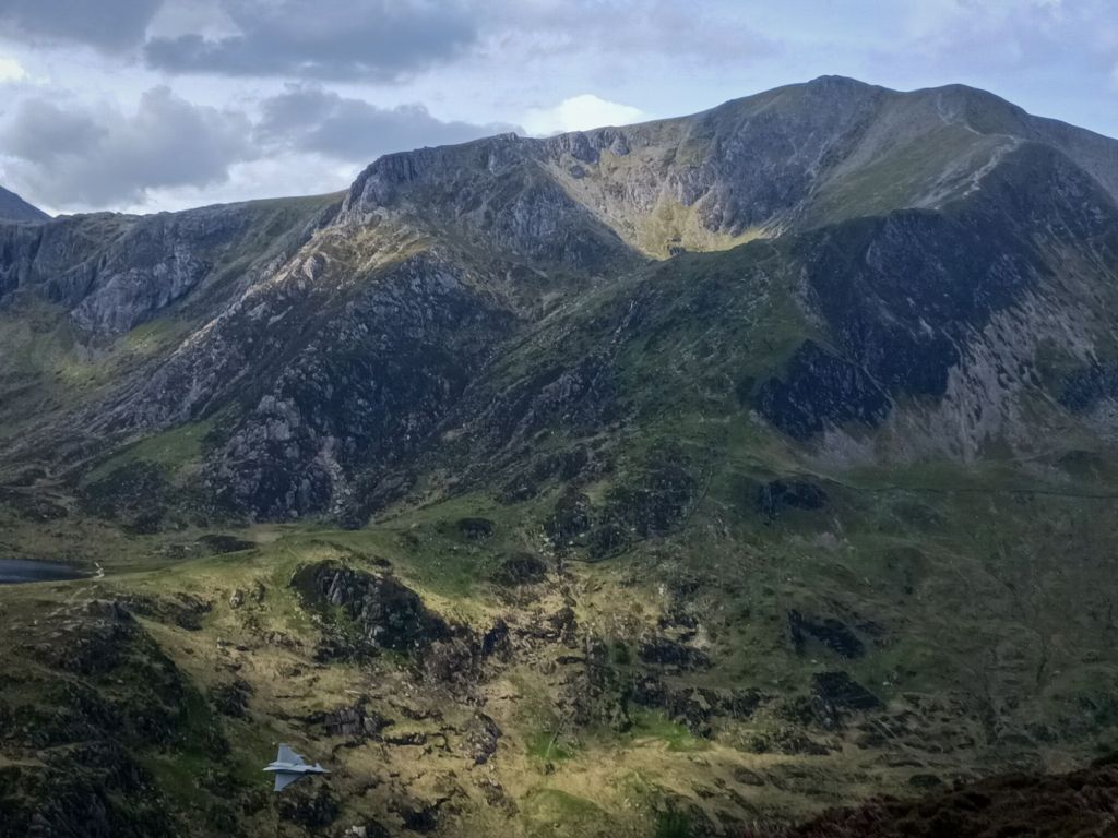
As we ascend the familiar roar of a fighter plane begins to echo down the valley and I just manage to get of a shot as it zips past us. The Ogwen Valley is on what’s known as the mach loop which is where fighter pilots train for low level flight training and this guy is low as a snakes testicle, hurtling over the top of Llyn Ogwen. This must be absolutely awesome to do, unless you mess it up of course. The roar of the jet echoes down the valley as the jet rapidly vanishes back into the sky which is growing increasingly moody. Meanwhile Llûr is firing off plenty of photos of his own while still searching for his favourite rock of the hike. Even though I’d originally thought this was just a thing my Welsh mates do nearly all my hiking friends do and I seem to be forever emptying pebbles out of my car.
Before the summit we find a cool little path which looks more like it should be in a garden than half way up a mountain, and is in it’s own way sort of surreal, however it makes for some cool pictures. From here we are joining the Cambrian way trail which takes us up the East side of Pen Yr Ole Wen.


The Western Carneddau
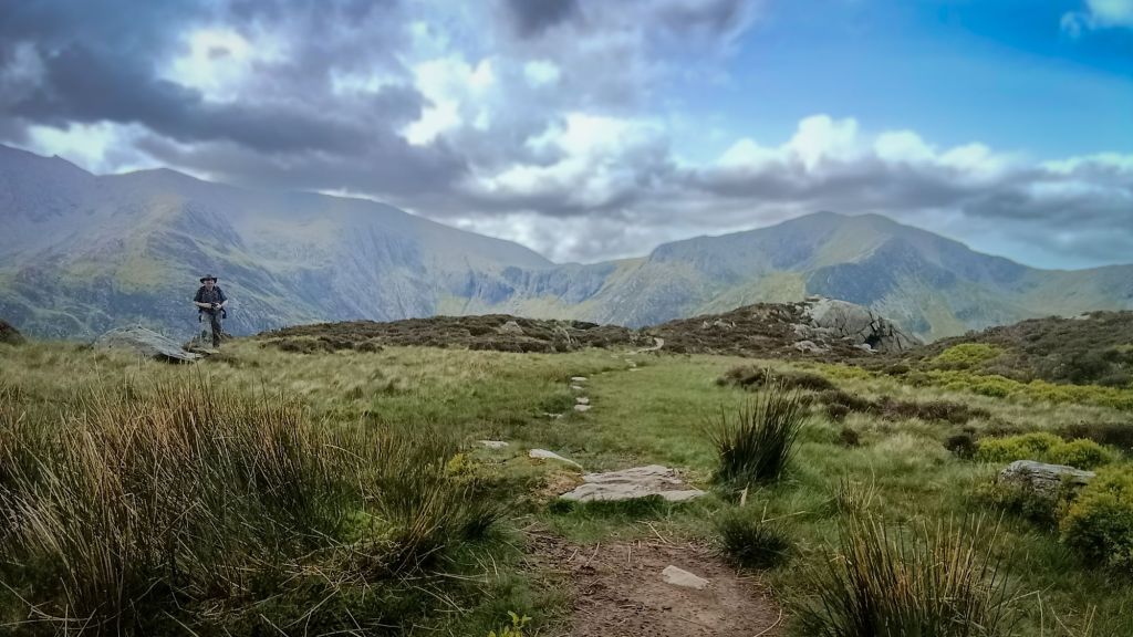
The summits here are aforementioned Pen Yr Ole Wen which we are about to summit , Carnedd Dafydd, Foel Meirch, Yr Elen, Carnedd Llewelyn and Pen Yr Helgi Du. It’s an area where you are more likely to see wild ponies than people, which is great because ponies are far more photogenic. I remember that I have in fact been across this way before during a failed attempt at the Welsh 1000m Peaks race where I’d twisted my ankles so badly the mountain rescue guys took one look at me and were like ‘you aren’t going to continue are you?’ anyway, obviously I took that as a sign. A sign it was better to give up then get my ass rescued later on somewhere harder to access anyway I’m still here to tell the tale so it was probably the right decision.
Pen Yr Ole Wen
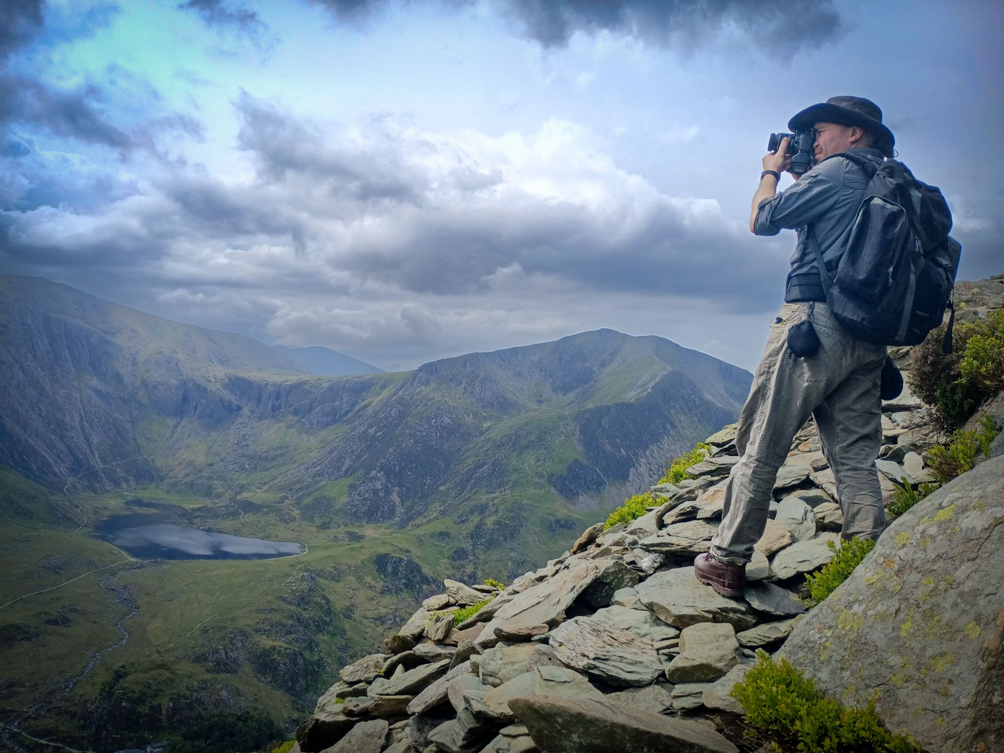
The last part of the very loose scree trail heads to the summit, which is a pain in the dry and grim in the wet, before long though we are on top looking back down into the Ogwen valley. Pen Y Ole Wen is the same height as England’s highest summit – Scafell Pike which is also 978 metres. Pen Yr Ole Wen is also the 7th highest mountain in Snowdonia, and part of the Carneddi Range. If you are interested in place names, the Welsh usually being quite literal the name Pen Y Ole Wen was originally thought to mean ‘head of the white light’ though recently has been corrected to ‘head of the white slope’. Maybe it’s something to do with the way the light shines on the mountain, or the way snow settles on it. We didn’t tackle it dead on here, but there’s nothing stopping you doing it if you don’t mind coughing out a lung – it’s very steep!

Carnedd Dafydd
English translation ‘David’s Cairn’ this could be named for Prince Llewelyn ap Gruffydd’s brother David who knows however, some things are lost to time. The summit stands at 1044m metres, with a small cairn on the top with a few walls.
Carnedd Llewelyn
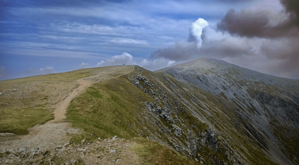
The Highest point of the Carneddi this is the Second highest Mountain in Wales at 1064m and though it isn’t as impressive as Yr Wydffra it’s still one you should see if you are a keen hiker. Plus you don’t have to take part in waiting in line for the summit like on Snowdon which is not what I go out in the mountains for. It’s name is Welsh for ‘Llwelyn’s Cairn’ and it’s come under some debate of if this refers to Llwelyn The Great who had a fortified observation post on the mountain or Llywelyn ap Gruffudd. Though it’s unclear I’d think that this shows whoever the Welsh meant here they must have had a good deal of respect for them. In more recent history on March 14th 1950 during night time exercises following an instruction to divert their course due to bad weather one of three Avro Lincoln RF511 aircraft crashed on Carnedd Llewelyn. Unfortunately all six of the crew members died from what’s was determined to be a misheard instruction of navigation. Though we did not see it ourselves the wreckage remains on the mountain with a memorial plaque that was placed on the crash site in 2002. I’m sure to some this site would be of interest to some however I’ve only learned of it since researching for this blog. I can imagine the crash site would make for some thoughtful and haunting photographs. The summit of Carnedd Llewelyn is occupied by an ancient cairn and the views on a good day enable you to look down to Cwm Eigiau, which is now obscured by cloud. As we have headed further into the mountains over our hike, the sky has gradually become more threatening with the patchy clouds and blue giving way to grey, though light showers have been predicted, the rain that comes in in true Welsh fashion is about as light as a cannonball and wetter than a sharks arse.

Our original intention of intention of forming a route down the hard to navigate valley below (which one) towards Bethesda for that always well earned pint we scrap almost instantly, as visibility is very low and it’s grim out here, so we double back which is the easiest and ‘should’ be the safest and quickest option. It just goes to show just how quickly the weather can change here.
All The Fun Of Descending Pen Y Ole Wen
What we haven’t factored in is the steep way down, now wet and far more dangerous. Llur decides to press ahead, I’m a bit slower at this point with my knees still badly effected by reactive arthritis recovery. I don’t mind him pressing ahead but he’s about the regret the decision Being as Llûr is ex MRT and I’m a trained mountain leader you’d think we’d have more sense than descending a scramble and loose rock spread apart but apparently not. Just as I’m thinking maybe I should call him and descend together I dislodge a rock and there’s enough space between us that it shoots off at some speed down towards him. I say it’s a rock but I guess what I really mean is small boulder. I’m quick enough to realise what’s happened and I shout ‘rock below!’ and he thankfully reacts in time, it misses anything vital and bounces off his heavy duty boot. If the rock had hit any higher I’d be carrying him back down. I guess that’s a lesson re learnt for the both of us, and at least my mate still has an intact leg. He still has to contend with a bruised foot on the way back down but it could have been a lot worse. Also a reminder that even people who are well trained can get complacent sometimes, nobody is infallible. We make it down the majority of the rest of the descent without any issues and then get confused on part of the route on the way down as the fog and rain has set in visibility isn’t so good. More than a few times we end up at a dead end, and I don’t chance climbing down anything, there’s always a temptation to cut corners at the end of a hike but it’s not worth getting injured to get to the pub faster. Of course we do finally get down and I drive to Bethesda where we sit in the pub looking like we just got put through a washing machine. It’s been a decent day out and I’ll have to be back at some point and see if I can find that plane crash site next time.
Interested in future articles, equipment reviews extreme adventures, travel and routes? Sign up to our upcoming newsletter below!
