


I’ve used a number of different GPS units over my time in the outdoors which to count has been around sixteen years so far and I’ve seen GPS technology come on leaps and bounds. I’ve used everything from mobile phones to very basic and far more complex GPS units. Because of me going on to train for a mountain leader qualification I wanted to get a unit that, should myself or my group get into difficulty and map and compass should fail me (which it shouldn’t) will help us out of a mess. And thats where the Garmin 66i comes in because not only is a great for navigation but it also has the Inreach functionality, which from a safety point of view really comes into its own.
Price: These units range from around £480-£560ish
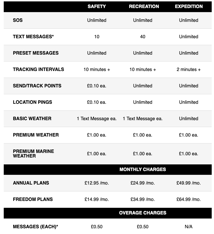
Safety /Emergency Features
I’ll start with talking about that, with this unit you get a built in in reach satellite service which if you pay the reasonable subscription means that you can send text messages, share your co-ordinates through the satellite system (no need for relying on a phone in mountain areas where there’s often no signal) and should everything go very wrong the unit has an SOS button function. Even better the messaging is two way so not only can you contact people but they can reply to to confirm they know you are ok. The SOS is even interactive so you can communicate directly with a search and rescue centre to tell them what the issue is. You can see the subscription plans below which for what they offer I think is more than reasonable. As we don’t all have the luck of being out in the mountains constantly (I do try) the monthly payment plan works very well for me. You don’t have to worry about accidentally setting of the SOS call button because its clearly labelled as you can see from the photos AND its protected under a large rubber cover, which is good for me as if it wasn’t I know I’d probably set it off by accident.
Communications in General
You can receive text messages on this device from other in-reach users which if you have an outdoor instruction business I can imagine would be pretty useful. If you have a Garmin watch or other some of these even allow you to connect with the unit and use some of it’s functionality from the watch itself, the full list of compatible devices are listed on the Garmin website.
Navigation And Sensors
A built in compass, barometric altimeter to monitor the weather and you altitude, GPS, Gallieo, all help to keep you on track. You can also get live weather for your location and where you are heading. I find navigating with this unit incredibly easy, and features like the unit vibrating in your pocket when you go off track are nice touches. With downloadable Birds eye maps you can have an overlay of the map information on top of satellite imagery which can help your nav accuracy even more however it’s not overly necessary. The unit is quick to work, there’s almost no lag and it takes hardly any time to connect to satellites. The unit features lots of preloaded points of interest and categories from local shops to places to stay and far more which is really hand when and if you mobile phone runs out of battery which it likely will before this does.
Interface
Some may complain about this feeling clunky with it’s large rubberised buttons and it’s similarity to let’s say an old Nokia phone. However think for a moment if its winter and you are wearing thick gloves, and now this won’t seem like such a terrible feature. In similar situations something like for example a touchscreen isn’t going to fare well in heavy rain of snow or if you get mud on it. It’s functional and it works, I know I’d prefer to have this if I’m out in winter than something pretending to be an iPhone.
Memory
It holds up to 250 tracks (trails) I’m yet to meet anybody who has hiked that many trails, but if they exist and they have a bad memory they are in luck here. It can also take a micro SD card and even more maps besides the base maps.
Accuracy
I see so many people saying that a mobile phone will do out in the mountains, and let’s be straight to the point it won’t plus they are not that accurate. And how can they be? Most tend to rely on networks )if you even have a signal, which the majority of the time you won’t. The Garmin can connect to a number of satellite networks in order to position you correctly, so well in fact the accuracy is to 3 metres of your position. Now don’t get me wrong there are phones now that can do this and connect to multiple satellites and so on but one as an example that shares only some of this units features (the iPhone 13 pro) comes in at…over £1k in price.
How Rugged Is It?
It’s rated IPX76, and that means it’s completely protracted from dust ingress and can be immersed in water of a depth of one metre for thirty minutes. It’s also rated to MIL-STD-810G which is a US military standard for thermal, shock and water which I’d love to detail here but take my word on it, this means it’s pretty damn solid. The outer body is rubberised and has a decent grip to it as well so you are unlikely to drop it, and even if you do it can handle it.
Connect IQ Compatibility
The addition of this I think is great as being able to access the connect IQ store means you can get Garmin’s extra apps and even third party apps for the device, I can’t say I’ve bothered using this yet but I do use Connect IQ apps on my Fenix watch which allow me for example to have different data displays and even change the data my watch displays. It just means you can really get in there and customise the unit if you wish.
Battery Life
If you use the unit for expeditions or long days out adventuring then this IS an important feature, and the unit boasts a battery life of up to 35 hours in standard mode or up to 200 hours in expedition mode. This turns everything running on the unit off until you wake it and takes a GPS fix far less often in order to preserve battery. I find this really handy as you won’t be looking at the unit all the time so when it isn’t in use it’s automatically saving battery.
Screen Type
The Transflective colour TFT screen means you can see the unit screen in any light conditions which is perfect for outings in the UK mountains where the weather can change in seconds.
Finally
Overall I’m seriously impressed with this unit, it’s a worthwhile investment (can you really put a price on safety?)and it gives me added confidence in the mountains, it’s easy to use and I like many Garmin devices I’ve had before, I cannot imagine not having one now. I’d give this 10/10 I genuinely don’t know how they could improve it!
